Kiczora Mountain
Kiczora Mountain – a peak at 1282 m a.s.l. in the Gorce Mountains. It is the third-highest peak in the Gorce Mountains. It is located in the Gorc Range, branching off from Turbacz and extending for several kilometers eastward to the Gorc Mountain. Kiczora borders Turbacz Mountain to the west through Przełęcz Długa (Long Pass), Stusy Peak to the south, and Trzy Kopce Peak to the north. Kiczora’s eastern slopes descend to the Forędówki Stream, its southeastern slopes descend to the Furcówka Stream, and its western slopes descend to the Łopuszanka Stream.
Two ridges branch off from the neighboring Trzy Kopce Peak, passing through Kiczora. The southern ridge descends to Knurowska Przełęcz (Knurowska Pass), and the southeast ridge runs through Góra Sucha (Sucha Mountain), Wierch Znaki (Znaki Peak), and the Ustrzyki settlement in Ochotnica Górna.
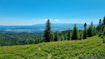
The peak is completely covered with upper montane spruce forest. On the southeastern slopes of Kiczora lies the Hala Młyńska (Mill Hall), which offers distant views of the Sącz Beskid Mountains, the Spiska Magura Mountains, the Pieniny Mountains, and the Tatra Mountains. In the forest on the western slope of Kiczora’s southern arm are the Turnice Rocks, home to the largest group of caves in the Gorce Mountains. These include the Rainbow Cave, Goszczyński Cave, the Abyssal Cave, Łopuszańska Cave, Kiczorska Cave, and the Szczelina za Płytą (Behind the Plateau).
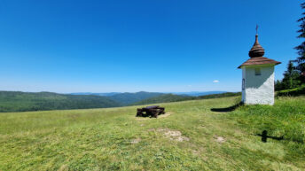
Kiczora is located within the Gorce National Park. Below the summit, the red-marked Main Beskid Trail, the green-marked “From Turbacz to Jaworzyna Kamienicka” educational trail, and the red Ochotnica Górna – Kiczora hiking trail intersect.
Hikes related to the tag KICZORA MOUNTAIN: