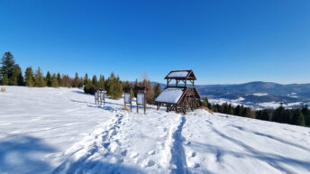

Rachowiec Mountain
Rachowiec Mountain – a peak at 954 meters above sea level in the Żywiec-Kysuce Beskid Mountains. It is located in the northwestern part of the Wielka Racza Group, on a side ridge that branches eastward from the keystone point called Gomułka and runs through Mały Rachowiec to Rachowiec. The western slopes of the Rachowiec ridge are cut by the valleys of streams flowing into Raztok, the largest of which is the Płaszczyna. Streams flowing into the Czerna River flow down the northeastern slopes, and the Rachowiec Stream flows down the southeastern slopes. The southern slopes descend to the Słanica Stream.
The forests growing on Rachowiec are consistent with the lower montane forest of the Żywiec-Kysuce Beskid Mountains. Due to the moderate elevation of the peak, mixed spruce-beech forests with some fir dominate here, with patches of Carpathian beech forest remaining in places. This complex has a mosaic character – it doesn’t form a compact forest, but is instead interspersed with clearings (e.g., Hala Rachowiecka) and ski infrastructure around Zwardoń. As in other parts of the Beskid Mountains, the local forest stand has suffered from the historical planting of artificial spruce monocultures. The spruce’s susceptibility to drought and the spruce bark beetle has necessitated the gradual conversion of the Rachowiec forests to more resistant deciduous species.
The Rachowiec peak is only partially forested. It offers sweeping views of the Silesian Beskid Mountains, the Mały Beskid Mountains, the Żywiec-Orawa Beskid Mountains with the dominant Pilsko Mountain, the Żywiec-Kysuce Beskid Mountains, and in the distance, the Tatra Mountains, the Little Fatra in Slovakia, and the Moravian-Silesian Beskids in the Czech Republic.
The red Rycerka – Sól hiking trail and the green Zbójnicka Ścieżka Trzech Harnasi hiking trail run through the peak.
Hikes related to the object RACHOWIEC MOUNTAIN: