Trzydniowiański Wierch
Trzydniowiański Wierch – a peak at an altitude of 1758 m a.s.l. in the Western Tatra Mountains. It is located on a long ridge extending northward from Konczysty Wierch, separating the Starorobociańska Valley from the Jarząbcza Valley. North of Trzydniowiański Wierch, the ridge branches into two branches, between which lies the Trzydniowiańska Valley. To the south, Trzydniowiański Wierch borders the Czubik peak through the Przełęcz nad Szyją (Silk Pass). On the eastern slopes of Trzydniowiański Wierch are the couloirs Mokry Żleb, Wydty Żleb, and Dwójakowy Żleb. On the western slopes, Szeroki Żleb is separated from Wąskie Żlebki by Pośrednia Kopa.
Trzydniowiański Wierch is composed of metamorphic rocks: alaskites interbedded with mylonites. On the northern slopes, the former Trzydniówka pasture stretched, giving the peak its name. On the western slopes, grazing took place on Hala Jarząbcza. Today, the upper reaches of the peak are covered with alpine grassland, including the scutum rush, which turns red in autumn.
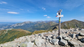
From the summit, views extend to the Western Tatra Mountains, the High Tatra Mountains, the Low Tatra Mountains, the Żywiec-Orawski Beskid Mountains, the Gorce Mountains, the Wyspowy Beskid, and the Sącz Beskid Mountains.
The red Chochołowska Glade – Trzydniówka Glade trail and the green Trzydniowiański Wierch – Kończysty Wierch trail intersect at the summit.
Hikes related to the tag TRZYDNIOWIAŃSKI WIERCH: