Tag - Magurki Mountain
Magurki Mountain – a peak at an altitude of 1108 m a.s.l. in the Gorce Mountains. It is located in a side ridge extending from Jaworzyna Kamienicka Mountain towards the south-east. It borders Jaworzyna Kamienicka via Pańska Przehybka Pass, and from the south-east it borders the Borsuczyny peak (1097 m a.s.l.). The northern slopes descend to the Jaszcze Stream and the southern ones to the Forędówka Stream.
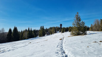
The peak is covered with forest, on its eastern side there is a vast Magurki Glade, from which there is a view of the Tatras and the Gorce Mountains. The north-eastern slopes of Magurki are covered with a lower montane mixed forest, which is located within the borders of the Gorce National Park. On the slopes descending to the Forędówka Stream valley there are the Poniechaniec, Mieredzysko and Kurnytowa Polana glades, and on the north-eastern slopes of the ridge there are the Tomaśkula and Szlagowa glades.
At the top there is an observation tower built in 2015, from which there is a panorama of the Tatra, Gorce, Low Beskid, Sącz Beskid and Pieniny Mountains.
The green-marked educational trail “Dolina Potoku Jaszcze” leads to the top from the Jaszcze hamlet in Ochotnica Górna.
Hikes related to the tag MAGURKI MOUNTAIN: