Tag - Majcherkowa Mountain
Majcherkowa Mountain – a peak at 1358 meters a.s.l. in the Żywiec-Orawska Beskid Mountains. It is located in the Lipowski Wierch and Romanka Group. To the south, it borders the slightly higher Romanka peak, and to the northeast, Kotarnica peak. The western slopes descend steeply to the Romanka Stream valley, while the eastern slopes descend steeply to the Sopotnia Stream.
Majcherkowa is the lower peak of Romanka. It is composed of Carpathian flysch, alternating layers of sandstone and shale, folded in the Cenozoic era during Alpine orogenic movements. These deposits formed on the seabed, and their uplift formed the present-day mountains. The high resistance of the cemented transverse fault zones resulted in the formation of transverse ridges rather than valleys. The relief of these ridges is the result of selective processes occurring in this area during the Pleistocene, and the slopes of the range are occupied by numerous deep structural rock slides.
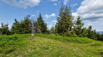
The summit of Majcherkowa is partially exposed. There is a glade overgrown with forest, offering a view of Babia Góra through a clearing between the trees. The slopes are almost entirely covered with forest. The upper montane spruce forest on the western slopes begins at an altitude of approximately 1,150 meters above sea level, and on the eastern slopes at approximately 1200 meters a.s.l. To protect it, the Romanka Nature Reserve was established in 1963. It encompasses the summit areas of Romanka and parts of Majcherkowa. Within the reserve, you can find impressive spruce trees, some 250 or even 300 years old. Currently, the spruce stand is under intense attack by the bark beetle, causing large swaths of trees to die. The lower parts of the slopes are covered by a mixed forest of the lower montane zone, consisting mainly of beech, fir, sycamore, and rowan.
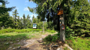
On the western side, the peak is bypassed by the blue Żywiec – Bystra Górna hiking trail.
Hikes related to the tag MAJCHERKOWA MOUNTAIN: