Tag - Ostry Wierch (Low Beskid Mountains)
Ostry Wierch – a peak with a height of 930 m a.s.l. in the Polish part of the Low Beskid Mountains, it is the second highest peak in the Polish part of this mountain range. It is located in the Ostry Wierch and Biała Skała range in the so-called Hańczowa Mountains. From the north-west it borders Biała Skała, from the south-east with the Cigelka peak. The northern slopes descend steeply to the Ropska Woda stream, the eastern slopes descend steeply to the Ropka stream and between them runs a short ridge from Ostry Wierch to the Hutniańska Pass. The southern slopes descend steeply to the Pułaski Pass and further to the Biała River.
Ostry Wierch is made of Carpathian flysch. These are alternating beds of conglomerates, sandstones and shales. Their formation is related to the deposition of soils in the mountain reservoirs, originating from the erosion of older mountains.
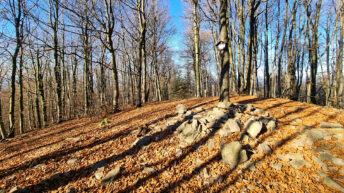
The peak and steep slopes are covered with forest, mostly the Carpathian beech forest characteristic of this region. In the lower parts, fir, spruce and even pine appear.
The yellow Ropki – Ostry Wierch hiking trail runs through the peak.
Hikes related to the tag OSTRY WIERCH (LOW BESKID MOUNTAINS):