Tag - Trzy Kopce (Gorce Mountains)
Trzy Kopce – a peak at an elevation of 1281 m a.s.l. It is located in the Gorc Range, branching off from Turbacz and extending for several kilometers to the Gorc Mountain in the east. To the west, through Długa Pass, it borders Turbacz (1,310 m a.s.l.), to the south, Kiczora (1282 m a.s.l.), and to the northeast, Jaworzyna Kamienicka (1288 m a.s.l.). The northern slopes descend to Borek Pass, the eastern slopes to the Forędówki Stream, and the southwestern slopes to the Łopuszanka Stream.
Trzy Kopce is the keystone for four ridges: the southern ridge, descending through Kiczora to Knurowska Pass; the southeastern ridge running through Góra Sucha, Wierch Znaki to the Ustrzyk settlement in Ochotnica Górna; The northeastern ridge, which is the Gorc Range, runs through Jaworzyna Kamienicka and Przysłop to Gorc; the northwestern ridge, which runs through Długa Pass to Turbacz.
The summit is rather unremarkable, completely covered with upper montane spruce forest. It is located on a flat plateau, which has resulted in the formation of a raised bog. It formed on poorly permeable soil and is fed solely by rainwater. The peat layer is currently estimated to be approximately 60 cm thick. The moist, peaty soil supports species rare in the Gorce Mountains, including cottongrass and bog blueberry. Both the summit and the higher slopes are covered with upper montane forest.
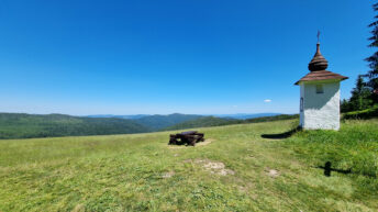
On the southeastern slopes is Hala Młyńska, which offers a distant view of the Sącz Beskid Mountains, the Magura Spiska Mountains, the Pieniny Mountains, and the Tatra Mountains. On the northern side of Trzy Kopce lies the almost completely overgrown Polanczyna Pasture.
Near the summit, you’ll find the green Grywałd – Gabrowska Glade hiking trail, the green-marked “From Turbacz to Jaworzyna Kamienicka” educational trail, and the red-marked Main Beskid Trail.
Hikes related to the tag TRZY KOPCE (GORCE MOUNTAINS):