Świętokrzyskie Mountains
Świętokrzyskie Mountains – a mountain range located in central Poland in the Kielce Upland – are among the oldest mountain ranges in Europe. To the north, they border the Suchedniów Plateau, to the east the Sandomierz Upland, to the south the Szydłów Foothills, and to the west, they border, for short stretches, the Nida Valley, the Przedborsko-Małogoskie Range, and the Łopuszańskie Hills. The highest peak is Agata, at 614 m (2,000 ft) above sea level.
The Świętokrzyskie Mountains are one of the most geologically diverse areas in Europe. Their history spans over 500 million years, during which the region has been repeatedly flooded by seas, uplifted (Caledonian, Hercynian, and Alpine orogenies), and eroded by erosion.
1. Paleozoic Era (Structure of the Core)
– Cambrian: Uplift of the oldest rocks – quartzite sandstones, which form, among others, the Łysogóry Mountains.
– Ordovician and Silurian: Marine periods. Sediments record traces of ancient volcanic activity and global glaciation.
– Devonian: The period of tropical seas. Limestone ranges (Kadzielnia, Chęciny) were formed at that time. The world’s oldest land-emerging tetrapod tracks were discovered in Zachełmie.
– Carboniferous: Intense orogenic movements (folds and faults, e.g., the Ślichowicki Fold) and the formation of mineral deposits (pyrite, “różanka” calcite).
– Permian: Formation of the famous conglomerates (e.g., the Sigismund conglomerate) and salt and gypsum deposits as a result of sea evaporation.
2. Mesozoic Era (Age of Dinosaurs)
– Triassic: Dominance of a warm, continental climate (the Tumlino Sandstones, with their footprints of the first dinosaurs, are a reminder) and periodic marine flooding (Muschelkalk).
– Jurassic: A time of tropical swamps and the great “Jurassic Flood.” Traces of life from this period (ammonites, dinosaur footprints) can be found in Gagaty Sołtykowskie and Małogoszcz.
– Cretaceous: Further marine sedimentation.
3. Cenozoic Era (Landscape Development)
– Paleogene and Neogene: Intensive weathering exposed the Paleozoic core of the mountains. The Miocene sea (gypsum and sulfur deposits) encroached from the south.
– Quaternary (Pleistocene): Glacial period. As a result of frosty weathering in the periglacial zone, characteristic boulder fields (rock rubble) and loess deposits formed.
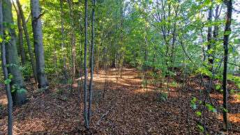
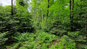
The Świętokrzyskie Mountains are largely covered with forests. One characteristic of the vegetation in this area is the presence of mountain forests, as well as upland and lowland forests. It is assumed that the boundary between mountain and upland forests coincides with the contour line at 350 m above sea level on the steep northern slopes and runs along the contour line at 450 m above sea level on the gentler southern slopes. In the lower zone, pine, pine-oak, and oak-pine forests occur. In the higher elevations, fir and beech forests predominate. The composition of the higher forests resembles the forests of the lower zone in the Beskid Mountains.
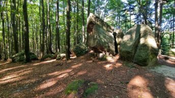
The Świętokrzyskie Mountains contain boulder fields. These are forestless areas (bare of coniferous forest) located on the slopes of mountain ranges. The boulder fields are composed of Cambrian quartzite sandstone blocks formed over 500 million years ago.
The boulder fields on Łysa Góra are among the largest areas of bare block cover in Central Europe, the largest of which, covering 3.84 hectares, is named after Professor R. Kobendza. These unique debris fields were formed in the Pleistocene (during the North Polish Glaciation) as a result of intensive frost weathering of quartzite sandstones. This process, occurring in the harsh periglacial climate, involved the breaking up of rocks by water freezing in crevices. The lack of finer sediments is attributed to solifluction processes, i.e., the movement of weathered material down the slopes.
The contemporary Świętokrzyskie mountain embankments are fossil forms, meaning that in current climatic conditions they no longer grow, but are slowly undergoing biological succession. This process progresses from the edges of the debris fields, where organic matter accumulates, allowing for the development of the pioneering Świętokrzyskie rowan community. The central parts of the block fields remain almost treeless, offering space only for mosses and lichens that can survive in extreme conditions of water and soil deprivation.
Despite its harshness, this environment is home to many natural curiosities, including rare invertebrates such as snails (e.g., the Alpine chrysalis) and numerous species of moss mites involved in the formation of initial soils. The rocks that make up the embankments are over 500 million years old and conceal traces of a Cambrian sea, including rare coral fossils. The entire ecosystem provides a fascinating field for observing soil-forming processes and the evolution of the landscape, from bare rock to mature fir-beech forest.
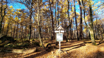
To protect the unique values of the Świętokrzyskie Mountains, the Świętokrzyski National Park and landscape parks were established within their area: Jeleniowski Landscape Park, Cisowsko-Orłowiński Landscape Park, Suchedniowsko-Oblęgorski Landscape Park, Sieradowicki Landscape Park, and Chęcińsko-Kielecki Landscape Park. The established nature reserves include: Jaskinia Raj (Paradise Cave), Bukowa Góra (Bukowa Mountain),The Michniowski Stone, Miedzianka Mountain, Białe Ługi, Stone Circles, Barania Góra, Chelosiowa Jama – Jaworznicka Cave, Karczówka, Kadzielnia, Piekło Pod Niekłaniem Rocks, J. Czarnocki Rock Reserve – Ślichowice, Zelejowa Mountain, Zamczysko, Sufraganiec, “Cisów im. Z. Czubiński” Reserve, Milechowy, Biesak-Białogon, Barcza Reserve, Szczytniak, Małe Gołoborze, Wąwóz w Skały, Perzowa Góra, Wietrznia, Zachełmie.
The Świętokrzyskie Mountains form parallel mountain ranges, stretching from west to east. The main axis is a series of ranges approximately 70 km long, beginning near Dobrzeszów in the west. It comprises the Dobrzeszów Range, the Oblęgorskie Range, the Tumlińskie Hills, the Masłowskie Range, the Łysogóry Range, and the Jeleniowskie Range, which ends near Opatów. This range is cut by the gorges of the Łosośna, Bobrza, Lubrzanka, and Słupianka rivers. South of the Łysogóry Range lies the small Bielińskie Range.
To the south of the main range, separated from it by the Kielecko-Łagowski Paddock, lies a range comprising the Zgórskie, Posłowickie, Dymińskie, Daleszyckie, Cisowskie, Brzechowskie, Orłowińskie, and Wygiełzowskie ranges. To the north of the Wygiełzowskie Range is the Iwaniskie Range. To the south of the Orłowińskie Range is the Ociesęckie Range.
To the southwest of the Dymińskie Range extend the Zelejowskie and Chęcińskie ranges, separated by the Chęcińska Valley. To the west of Chęciny lie two small mountain ranges: the Grzywy Korzeczkowskie and Grząby Bolmińskie. To the northeast of Chęciny lies the Bolechowickie Range.
To the north of the main range lie the Klonowskie Range, the Bostowskie Range, and the Pokrzywiańskie Range, while further north lies the Sieradowickie Range.
In and around Kielce are the Kadzielniańskie Range and the Szydłówkowskie Hills.
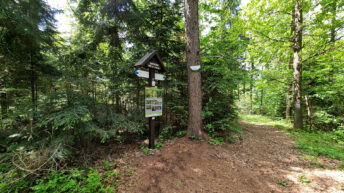
Numerous hiking, walking, and educational trails have been established in the Świętokrzyskie Mountains.
Hikes related to the tag ŚWIĘTOKRZYSKIE MOUNTAINS: