Tag - Ondřejník
Ondřejník – a peak 890 m a.s.l. in the Podbeskydy Uplands. It is the northernmost peak in the Ondřejník Massif. The massif stretches from south to north, with a slight deviation towards the east, in the form of a range about 8 km long and less than 3 km wide. From the east, the range is limited by the valleys (from the south) of Čeladenkai and Ostravice. In the south, they are separated from the Moravian-Silesian Beskids by a wide pass (about 480 m a.s.l.). The next peaks of the massif towards the south are: an unnamed peak (903 m a.s.l.), Stanovec (899 m above sea level) and the highest peak of the Skalka massif (964 m a.s.l.). On the southern slope of the Ondřejník massif, there is the Skalka nature reserve, which has existed since 1955. It was established to protect natural beech forests with the presence of spruce, maple, ash and fir. In some places in the reserve, the trees are almost 200 years old.
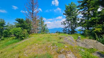
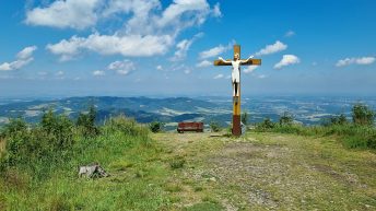
The peak is currently not covered with forest, but in the past the entire Ondřejník massif was densely forested with spruce forests. The bark beetle disaster in 2015 required the cutting down of most of the forest cover. In 2020, work began on reforestation of the entire massif. The peak offers a view of the Podbeskydy Uplands and the Moravian-Silesian Beskids.
Below the peak of Ondřejník, on the south-eastern side, there is the Ondřejník tourist cottage, which was built by the Czech Tourist Club in 1906-1907 and expanded in 1930.
Hikes related to the tag ONDŘEJNÍK: