Virtual hike: Ascent to Keprník Mountain from Ramzová, Czech Republic
Route: Ramzová – lanovka (782 m a.s.l.; 50.191666, 17.069094) – Nad Dobrou vodou (975 m a.s.l.; 50.179359, 17.069212) – Černava Mountain (1103 m a.s.l.; 50.179283, 17.078546) – Šerák crossroads (1319 m a.s.l.; 50.184585, 17.109225) – Sedlo pod Keprníkem Pass (1282 m a.s.l.; 50.181528, 17.112814) – Keprník Mountain (1423 m a.s.l.; 50.170960, 17.116403)
Trail designation: red trail, path marked on the map
Length: about 6.8 km
Walking time: about 3:00 h
Sum of approaches: 680 m
Sum down: 40 m
00:00:18 Ramzová – lanovka
00:16:50 Dobrá Voda Spring
00:26:15 Nad Dobrou vodou
00:27:24 Going off the trail
00:28:05 Spring
00:32:08 Ramzovská chata
00:46:03 Černava Mountain
00:51:58 Red trail
01:34:18 Šerák crossroads
01:41:04 Sedlo pod Keprníkem Pass
02:05:34 Keprník Mountain
Keprník Mountain – a peak at an elevation of 1423 m a.s.l. in the High Ash Mountains, in the Eastern Sudetes. It is located in the Keprník Massif, in the northwestern region of the High Ash Mountains. It is the fourth-highest peak in the High Ash Mountains. To the north, through the Sedlo pod Keprníkem Pass, it borders Šerák Peak; its northeastern slopes descend into the Keprnický Potok Valley; to the east, through a shallow pass, it borders Žalostná Peak; its southeastern slopes descend into the Rudohorský Potok Valley. The southern slopes of Keprník descend to the Trojmezí Pass, from which two ridges branch off: the eastern one towards Červená Hora Peak and the western one towards Vozka Peak. The western slopes descend into the Jelení potok and Klepáčský potok stream valleys.
The mountain’s area (slope area) is estimated at approximately 7.5 km², and the average inclination of all slopes is approximately 12°.
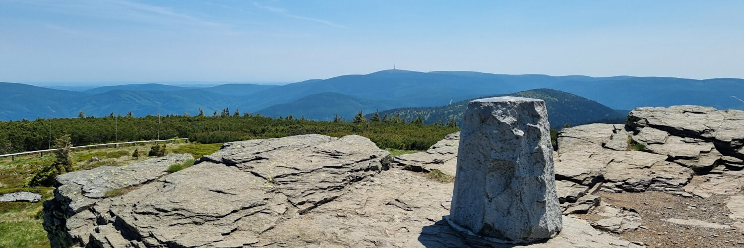
The Keprník Massif is composed of metamorphic rocks, primarily gneisses (biotites), orthogneisses, erlans, mylonites, blasto-mylonites, migmatites, mica schists, and igneous rocks, primarily metagranites. The geological structure also includes some admixtures of precious minerals such as staurolite, andalusite, garnet, and sillimanite. The summit features cryoplanation terraces and rock steps—frost cliffs—formed during the Pleistocene, in a frosty periglacial climate. At that time, a small mountain glacier likely existed on the southeastern slope, leaving behind the so-called Keprnický Kar.
Several streams originate on the slopes of Keprník: Jelení potok on the southwestern slope, Klepáčský potok on the western slope, Keprnický potok on the northeastern slope, and Rudohorský potok on the southeastern slope. Small marsh areas occur on the southwestern and southern slopes at elevations of approximately 1,320 and 1,300 meters above sea level. Most of the streams flowing down from Keprník contain waterfalls: Jelení vodopády (1015–1110 m above sea level), Keprnické vodopády (1115 m above sea level), Rudohorské vodopády (850–1075 m above sea level), Bystrého potoka (1000–1020 m above sea level), Vodopády pod Morickou (1015–1120 m above sea level), and Ve Stržích (1115–1160 m above sea level).
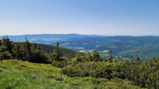
The summit is exposed, with a cryoplanation terrace bordered by a frost cliff. From here, you can enjoy distant views of the peaks of the Hrubý Jeseník Mountains and, in the distance, the Karkonosze Mountains, the Śnieżnik Massif, the Silesian Beskids, the Moravian-Silesian Beskids, the Malá Fatra, and the Western Tatras.
The summit of Keprník is covered by alpine meadows, with artificially planted dwarf pine growing at the upper treeline. The slopes from approximately 1,200 m above sea level are covered by upper montane spruce forest, while lower montane mixed forests, dominated by spruce and extensive beech forests, grow below.
The summit and the upper parts of all slopes are located within the Šerák-Keprník National Nature Reserve, part of the Jeseníky Protected Landscape Area, established to protect a number of preserved rock and soil formations formed as a result of the harsh climate of the Ice Age, including cryoplanation terraces, frost horsts, and tufurs, as well as the flora and fauna found within them.
The red-marked Rýmařov – Nad Boudou hiking trail runs near the summit.
The hike recorded on June 13, 2025.