Virtual hike: Udórz Castle through the Udorka Valley, Poland
Route: Kąpiele Wielkie, camping site (364 m a.s.l.; 50.431333, 19.743494) – Udórz Rock (345 m a.s.l.; 50.441798, 19.765939) – Udórz Castle (358 m a.s.l.; 50.445007, 19.769185)
Trail designation: yellow trail
Length: about 2.8 km
Walking time: about 0:50 h
Sum of approaches: 41 m
Sum down: 43 m
00:00:17 Kąpiele Wielkie, camping site
00:09:53 Udorka Stream
00:22:20 Udorka Stream
00:25:33 Udorka Stream
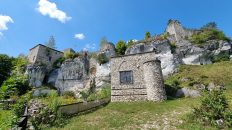
00:26:00 Udórz Rock
00:33:38 Going off the trail
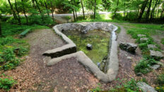
00:37:19 Udórz Castle
Udórz Castle – the ruins of a medieval castle in the Kraków-Częstochowa Upland. It is located on the western slopes of Zamczysko Hill. The steep slopes of the hill here are surrounded on three sides by the Udorka Stream, a tributary of the Pilica River in its upper reaches.
The castle’s construction dates back to the turn of the 14th and 15th centuries. Its founder is believed to have been Iwo of Obiechów, bearing the Wieniawa coat of arms, who served as the governor of Kraków from 1398 to 1400 and later as the starost of Ruthenia.
Archaeological research from 1987–1988 and 1990 revealed ramparts in the shape of an irregular pentagon, with no trace of any buildings within the ramparts, suggesting that the stronghold was never completed. The complete lack of historical records about the castle supports this hypothesis.
Fragments of two brick walls and an earth rampart remain to this day. The hillsides here are covered with beech forest.
The yellow-marked Smoleń Castle – Udórz hiking trail runs near the castle.
Hike recorded on August 2, 2025.