Virtual hike: Descent from Pilsko Mountain through Uszczawne Wyżne to Korbielów, Poland
Route: Pilsko Mountain (1557 m a.s.l.; 49.527970, 19.316799) – Góra Pięciu Kopców (1533 m a.s.l.; 49.531090, 19.318797) Hala Miziowa (1271 m a.s.l.; 49.541178, 19.317819) – Hala Mizowa PTTK Mountain Shelter (1271 m a.s.l.; 49.540217, 19.318807) – Górowa Rock (1233 m a.s.l.; 49.544015, 19.308220) – Jodłowcowa Glade (1167 m a.s.l.; 49.548978, 19.305425) – Buczynka Pass (1115 m a.s.l.; 49.553896, 19.303499) – Uszczawne Wyżne Mountain (1145 m a.s.l.; 49.557171, 19.303676) – Uszczawne Glade (1055 m a.s.l.; 49.560219, 19.309410) – Malorka Mountain (1051 m a.s.l.; 49.562502, 19.313487) – Przysłopy Pass, crossing (858 m a.s.l.; 49.575412, 19.316049) – Korbielów, parking (602 m n.p.m.; 49.575565, 19.343614)
Trail designation: yellow trail, green trail, black trail, blue trail
Length: about 9.5 km
Walking time: about 3:00 h
Sum of approaches: 977 m
Sum down: 23 m
00:00:18 Pilsko Mountain
00:13:54 Góra Pięciu Kopców
00:24:08 Pilsko Reserve
00:51:43 Miziowa Glade
00:53:17 Hala Mizowa PTTK Mountain Shelter
00:55:03 Kamienny Stream
01:00:14 Chapel
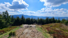
01:09:49 Górowa Rock
01:20:58 Jodłowcowa Glade
01:29:51 Buczynka Pass
01:31:10 Chapel
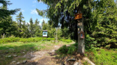
01:31:44 Going off the trail
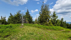
01:36:44 Uszczawne Wyżne Mountain
01:39:31 Black trail
01:48:42 Uszczawne Glade
01:52:01 Going off the trail
01:57:20 Malorka Mountain
02:02:21 Black trail
02:24:26 Chapel
02:24:36 Przysłopy Pass, crossing
02:35:34 Stream
02:45:22 Stream
02:50:21 Stream
02:56:55 Buczynka Stream
02:58:32 Korbielów, parking
Uszczawne Wyżne – a peak with a height of 1145 m a.s.l. in the Żywiec-Orawa Beskid Mountains. The name Gawory also appears on topographic maps. It is located in a ridge extending north from Pilsko.
Hike recorded on September 6, 2024.