Virtual hike: Descent from Świerzowa Mountain through Magura Mountain to Świątkowa Wielka, Poland
Route: Świerzowa Mountain (802 m a.s.l.; 49.565905, 21.434506) – Unnamed peak (746 m a.s.l.) – Świerzowa Glade (710 m a.s.l.; 49.575179, 21.395067) – Magura Mountain (829 m a.s.l.; 49.570431, 21.373821 ) – Majdan Pass (625 m a.s.l.; 49.560442, 21.368476) – Świątkowa Wielka, border of the Magura National Park (461 m a.s.l.; 49.543111, 21.415855)
Trail designation: red trail, yellow trail
Length: about 9.3 km
Walking time: about 3:00 h
Sum of approaches: 122 m
Sum down: 456 m
00:00:04 Świerzowa Mountain
00:14:07 Unnamed peak
00:20:08 Świerzowa Glade
00:53:11 Crossing of trails
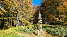
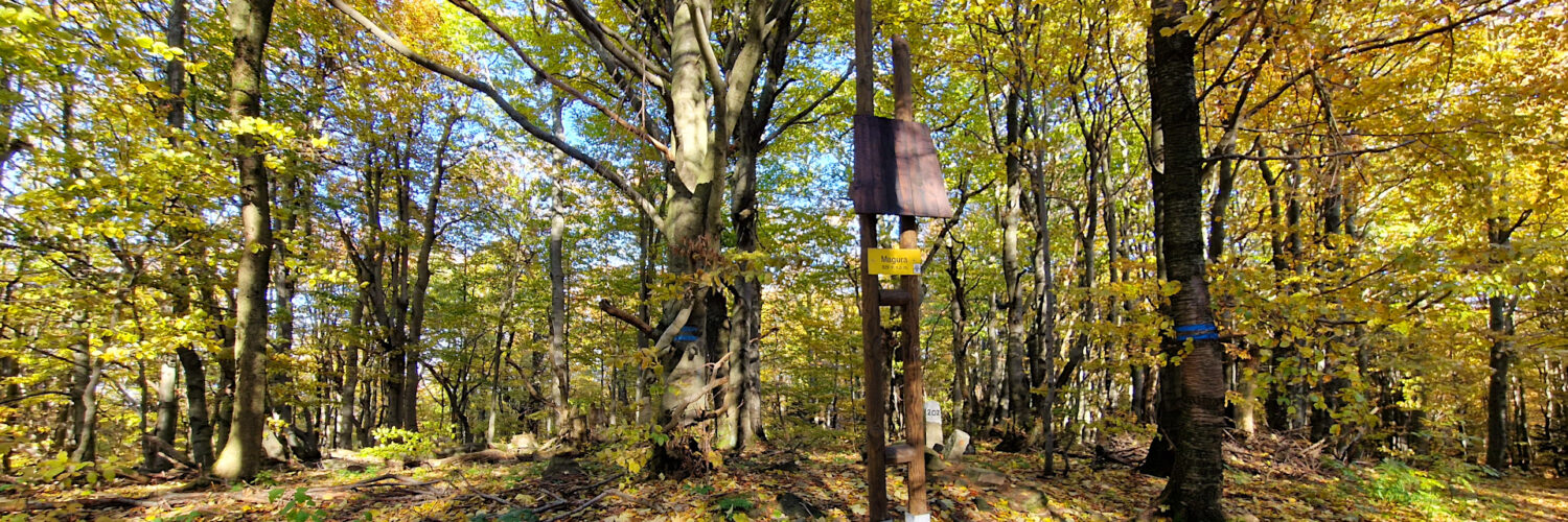
00:54:44 Magura Mountain
01:00:05 Crossing of trails
01:19:54 Majdan Pass
01:37:58 Świerzówka Stream Valley
01:38:51 Świerzówka Stream
01:43:22 Świerzówka Stream
01:46:30 Świerzówka Stream
01:48:28 Chapel
01:49:33 Świerzówka Stream
01:53:08 Chapel
01:54:18 Świerzówka Stream
01:59:19 Chapel
02:02:41 Chapel
02:04:13 Dugout cellar
02:06:05 Świerzówka Stream
02:09:00 Świerzówka Stream
02:10:30 Świerzówka Stream
02:23:27 Chapel
02:29:51 Świątkowa Wielka, border of the Magura National Park
Magura Mountain – a peak at an elevation of 829 meters a.s.l. in the western part of the Low Beskid Mountains. It is located in the main ridge of the Magura Wątkowska Range, in its central part. To the northwest, it borders the summit of Wątkowa and to the east, the eastern summit of Kornuty. The southern slopes descend to the Majdan Pass, which connects Magura with the summit of Mareszki. The northern slopes descend to the Kłopotnica Stream.
Magura, like the entire Magura Wątkowska Range, is composed of sedimentary rocks formed millions of years ago on the bottom of a former ocean. It belongs to the Magura Nappe – the largest and highest structural unit in the Flysch Carpathians. It is composed of so-called flysch, or alternating layers of sedimentary rocks. These are thick-bedded Magura sandstones, hard and highly resistant to weathering and erosion. These rocks form the highest parts of the Magura ridge and are responsible for its steep northern slopes. Clay shales and marls, on the other hand, alternate with sandstones, being much softer and more susceptible to erosion. Water more easily carves valleys and passes through them.
Magura, like neighboring Świerzowa and Wątkowa, owes its height to the phenomenon of landform inversion. Tectonic-wise, this ridge is a syncline (i.e., a geological trough/concavity). However, because thick and exceptionally resistant layers of Magura Sandstone were deposited within this trough, erosion spared the area. Neighboring anticlines (protrusions), composed of softer shales, were eroded over time by rivers and turned into valleys, while the hard Kolanin Syncline remains in the landscape as a high, steep mountain ridge.
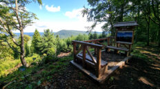
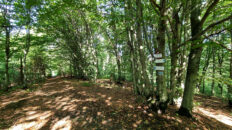
The summit of Magura is forested. Only on its western side is a small glade overlooking Lackowa and Magura Małostowska, and between them, on clear days, the Tatra Mountains can be seen. The summits and slopes of Magura, up to an elevation of approximately 550 meters above sea level, are covered by a primary lower montane forest. Fertile Carpathian beech forests dominate here, consisting primarily of European beech, silver fir, and sycamore. The undergrowth consists primarily of glandular honeysuckle, snowdrop, bear’s garlic, and wood anemone.
The Świerzówka and Rzeszówka streams, left-bank tributaries of the Wisłoka River, originate on the southern and southeastern slopes of Magura. The Kłopotnica stream, also a left-bank tributary of the Wisłoka River, originates on the northern slopes of the massif.
The red-marked Main Beskid Trail and the green-marked Gorlice-Kečkovce hiking trail run through the Magura summit.
Hike recorded on October 20, 2025.