Virtual hike: Descent from Čertův Mlýn Mountain through Tanečnice Mountain to Kunčice pod Ondřejníkem, Czech Republic
Route: Čertův Stůl Rock (1196 m a.s.l.; 49.488424, 18.301874) – Čertův Mlýn Mountain (1206 m a.s.l.; 49.489153, 18.301639) – Skalka Mountain (1037 m a.s.l.; 49.492336, 18.288038) – Tanečnice Pass (1010 m a.s.l.; 49.492321, 18.282294) – Tanečnice Mountain (1084 m a.s.l.; 49.494167, 18.275940) – Bystrý Waterfal (728 m a.s.l.; 49.499704, 18.295445) – Kunčice pod Ondřejníkem, Pod Stolovou – koliba (589 m a.s.l.; 49.522028, 18.308223)
Trail designation: red trail, green trail, paths marked on the map
Length: about 8.3 km
Walking time: about 3:00 h
Sum of approaches: 131 m
Sum down: 733 m
00:01:50 Čertův Stůl Rock
00:09:19 Čertův Mlýn Mountain
00:35:56 Going off the trail
00:36:23 Skalka Mountain
00:38:12 Return to the red trail
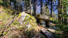
00:38:37 Rocks
00:45:45 Tanečnice Pass
00:56:00 Tanečnice Mountain
00:59:39 Going off the trail
01:10:46 Green trail
01:29:04 Waterfall
01:42:47 Bystrý Waterfal
01:45:45 Bystrá River
01:46:51 Going off the trail
02:35:21 Yellow trail
02:46:27 Kunčice pod Ondřejníkem, Pod Stolovou – koliba
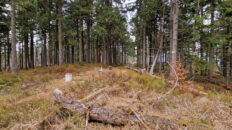
Tanečnice Mountain – a peak at an elevation of 1084 m above sea level in the Moravian-Silesian Beskids in the Czech Republic. It is located on the main ridge of the so-called Radhošťská Hornatina, bordering Skalka (1037 m) to the east and Radegast (1106 m) to the southwest via the Pustevny Pass. To the north, a side ridge extends, with the peaks of Zmrzlý Vrch and Nořičí Hora, descending into the Bystrá River valley, separating the Malá Ráztoka Stream valley from the Bystrá River valley in its upper reaches. The southern slopes, separated by a short ridge, descend to the Kněhyně Stream.
The peak is covered with a lower montane spruce-beech forest and offers no views.
The red-marked Hlavatá – Ježánky hiking trail passes through the peak.